Serving the Lord, helping the kids, and spending the last third of my life working my way back to the place where I can hang with the boy.

Thursday, February 22, 2018

Cape Horn

Day 8 - Cape Horn and Fake Horn


I have to start my blog on Cape Horn with a shout out to Mickey Live.  Mickey did daily lectures on our cruise and in the case of Cape Horn, This bit of history came from him.  I also need to use a few of his slides and Windy.com (which he told me about) To tell the story.

Let's start with his picture as the cover photo (because if I used the one I took it would look like this:

Cape Horn was a little Foggy as we went around the southern side

Ok, enough about the photography and on with the learning crap!

Location of Cape Horn
Prior to the Panama Canal, going around the southern side of Cape Horn was the only way to get from the Pacific Ocean side of the planet to the Atlantic Ocean Side. 
(That isn't entirely true, you could go the other way, traverse the Indian Ocean then sail between the southern tip of Africa and Antarctica to do it)

I can't remember a time when I wasn't aware of Cape Horn but it has become much more personal for a number of reasons.  One of them is this:

My little daughter at the north side of Cape Horn
My little daughter went there with me.  (That's right, she's 31 and although I don't call her Pook very much anymore, she will always be my little daughter).

Another reason was that being there was a bucket list level life experience, but most of the reasons were related to a bunch of cool stories that helped us learn more about Cape Horn.  This post is about my favorite story.  Favorite not because it was wonderful, favorite because it is powerful.

Let's start with the geography.  Our story takes place here:


The picture above shows where the archipelago that contains Cape Horn.  


So take a look just north west of Cape Horn.  There is another island called Island Hershel.  The story is about two things, what the islands look like, and what the wind is doing.  The star of our story is Hershel Island which was commonly referred to as "Faults Horn".  Mickey Live shared this slide:


Looking at the picture on the top of this page, you see that Cape Horn can be identified by a 656 foot tall hill that looks like a horn.  If you look at the southern side of Hershel Island (Faults Horn) on Mickey's slide, you can also see that Hershel Island also has a 656 foot tall hill.  

So imagine you are the captain of a three masted sailing ship in the mid 1700s.  As you came down the western edge of South America you were tacking into gentle winds ranging from 8 to 15 miles an hour.  You and the crew were relaxed.  You reach the bottom of the continent and start your turn eastward.  Now you have the wind on your stern (behind the ship) and it's speeding up so you are scooting along at a quick pace.  You know just what you need to do, and it is this:

What You Want To Do With Your Ship
You watch for the horn because in these winds you need to start the turn as soon as you see the horn (and before you reach it).  It's a grey overcast day but you get lucky and the skies clear enough that you catch a glimpse of the 656 foot tall hill that looks like a horn.  You give the command for a hard turn toward the port side (left for you land lubbers) and the ship turns putting you on this track:

Course when you turn after seeing the False Horn
Let's say that 30 seconds into your turn the fog clears enough that you suddenly see the real Horn shaped hill off your starboard side (the wrong side, but you saw it early so you are in the best case scenario).

Before I go on, let's talk about the wind.  

There is a website called "Windy.com" that you should be playing with if you aren't currently doing so.  It shows what the wind, rain, snow, temperature, and waves are doing at any point in time.  It shows everyplace on earth and shows it all the time.  I went out to that site and looked at the current winds while I was writing this blog and did a snapshot of the winds at Cape Horn right now:

Winds of the Drake Passage Feb 22nd 2018 @ 9:18 p.m.
The little white lines show the direction of the wind.  The color underneath shows how fast they are blowing.  9:20 at night is right around dusk so the winds were more calm than usual.  Typically the wind through here is anywhere from a low of around 40 mph up to hard winds that are over 140 mph.  When we came to Cape Horn they were around 70 mph and we were told we got lucky because the winds "weren't as strong as they normally are".   So, back to our story.

You had just transitioned from tacking into a 15 mph head wind which had you running with forward speed or 5 or 6 mph.  Turn the corner and you suddenly pick up an 80 to 90 mile an hour tail wind.

As you accelerate to what might be the fastest sailing speed you have ever experienced you spot the horn, give the order, make the turn and 30 seconds later you see the real horn on the wrong side of the ship.  

Hopefully you don't check the charts to see what happened or you will use more precious time.  If you had the charts memorized you would realize that instead of the Atlantic Ocean it's about 2 and 3/4 miles straight ahead to this...

Actual picture of where your ship is currently headed

...and at your current speed and direction you have about 90 seconds left until you hit it.  Time for a decision.  Quickly because 10 of your 90 seconds have lapsed while were recognizing what was happening.  Like me, your little daughter is on the ship with you.  What do you do?  GO!!

Well, I don't know what you did but most of the captains who made that mistake hit the rocks and sunk their ships.  The water is below freezing and if your crew (and little daughter) didn't die from the impact they probably got less than 5 minutes in the icy waters prior to hypothermia shutting all their muscles down.

As we rounded that corner (coming from east to west) I stood on the deck in 70 mph winds and imagined what it would have been like in my mind as I made that mistake (as many did).  It was a grave thought.  It was emotional.  It was educational.

And now, as my Dad used to say...you have been educated.

Tuesday, February 20, 2018

The End of the World


Ushuaia, Argentina - The End of the World
Really?


Ushuaia, Argentina.  El Fin Del Mundo.  The end of the world.  From the harbor you see a wall that says:

"USHUAIA end of the world, beginning of everything"

They call Ushuaia the end of the world because it is the southern-most city on planet earth.  They have a lighthouse called "The Lighthouse at the end of the world" and you can buy all manor of trinkets that say "End of the World" on the front (and "Made in China" on the back).

For Mandy the end of the world was the beginning of mental joy.  She was thrilled to get off the ship and walk around on dry land.  For me, it was a pleasant visit with memories that found my mind challenging the city's famous tag line. This post is about why.

First of all, here's what the bottom of South America looks like:


Argentina is shown in yellow.  The brown country on the west (and south) side of the country is Chile.  It is bordered on the east by Uruguay and Paraguay.  To the north is the Bolivian border.  For this discussion I don't care about the north or east, but let's consider Chile.

The town of Ushuaia is on Tierra del Fuego which is the largest one of many islands at the southern end of south America.  The eastern half of the Island is Argentina and the western half is Chile. 

Angentina / Chile Border in Yellow

The image above shows Tierra del Fuego with a yellow border drawn to show you what is Argentina and what is Chile.  The photo below circles the Chilean portion in red.


Ok, so now you've got a lay of the land.  The waterway below Tierra del Fuego is the Beagle channel.  Let's take a closer look at the channel.


Our trip to Ushuaia required we sail on the southern side of the Beagle Channel because the water is deeper there (and our ship was quite large).  For this reason we had to have a Chilean pilot aboard (to keep us from sinking our ship in Chile's channel).  About 40 minutes prior to arriving in Ushuaia we stopped at Port William Chile to offload the Chilean pilot and pick up one from Argentina.

(For those of you who don't track such things, big ships have to hire local pilots who know the conditions of the sea floor to guide them in and out of ports.  This is done at nearly every port.)

Port William, Chile is a picturesque little town nestled in between some beautiful mountains on the south side of the Beagle Channel.  Here's a picture I took of Port William as we changed pilots.

Port William, Chile

Some of you are racing ahead to where I'm going here.  How could Port William be a town six miles south of the southern-most city on earth?  To that my response is simply:

"Don't get ahead of yourself, you ain't seen nothing yet".


As you already saw, Port William, Chile is six miles south of the end of the world but if we zoom back a bit with Google Earth we see that Cape Horn Chile (the true southern-most point in South America) is about 90 miles south of Port William.  It has full time residents and a lighthouse that is tended (full time) by the Chilean Navy.

So...

That means there is a lighthouse close to 100 miles south of the lighthouse at the end of the world.  Hopefully you head didn't explode quite yet, because I'm not quite done.  Two brothers (Bartolome and Gonzalo de Dordal) were sailing on a Portuguese expedition in 1619 and nearly 400 years to the day prior to Mandy and I arriving they found this:

Diego Ramirez Islands
The cosmographer on board was named Diego Ramirez so obviously they would name these islands that are 68 miles south east of Cape Horn after him.  Fast forward 400 years and here's what you will find on these islands:

The Settlement 150 miles south of the southernmost place on earth 
You will also find this...

The lighthouse 150 miles south of the lighthouse at the end of the world
...so anyway, I'm not going to try to convince you one way or the other but I ask you this question.  When I sent my little grandson a sweater vest that had a little penguin on it with the caption:

Ushuaia  El Fin Del Mundo.
(hey, the kid's smart and I'm going to make him work for it)

What did I do?  Did I:
  1. Set him up to walk around sporting a bald face lie?
  2. Agree with the folks in Argentina regardless of what the goobers in Chile believe

             or
  3. Dip into logic that starts out with "Hey, it works for Santa Clause so ..."


Krill


If you want to see wildlife, you think about places like Africa and India.  You don't typically think about Antarctica, but a little know fact is that there are more animals in Antarctica than any of the other six continents.

What is the most successful abundant animal species on earth?  According to the Department of the Environment in Australia, the national geographic and many other knowledgeable sources, the answer is the Antarctic Krill.

I've written a number of articles talking about this animal or that animal that I hope to see on my trip to the south polar region and many (most) of those articles talk about krill being a primary food source.

So what is krill?


Krill are crustaceans, and are related to shrimp and lobster.  There are 85 known species of krill living in every ocean around the world.

Krill are small.  The average one is three quarters on an inch long.  The biggest ones can grow up to about two and a third inches long and weigh less than half an ounce.

Krill are numerous.  They swim together in enormous groups called swarms.  The swarms are so large that they can be seen from space on images taken by satellites.

The most plentiful species of Krill is the Antarctic krill.  If you took all the humans in the world and put them on one side of a balance scale, then put just the krill in Antarctica on the other side, the krill (at less than half an ounce each) is the heaviest.  In fact, the biomass of the krill in Antarctica is greater than the biomass of any other animal species on earth. 

Krill outnumber any other multi-celled species on the planet with somewhere between 32 trillion and 384 trillion of them within the waters of Antarctica alone.  (between 500 million and 6 billion tons)

Finally, there's this:

Duckling close up

This is a duck.  They are less plentiful than krill in both biomass and number of individuals.  That said, a baby duck is much cuter than a krill of any age.

and...As my dad used to say...Now you've been educated.

Whales


If you are going to hang out with whales, there are many types to choose from.  It seems like there are some automatic goals when you are heading toward the south pole.  

Probably first of all, you hope to see penguins.  You just don't ever get to do that up north where we live.  If you want to hang with penguins you pretty much have to travel to Australia, New Zealand, South Africa, South America, or Antarctica. 

The second thing you think of is probably mountains and ice.  I should have said icebergs and although I did see literature about that when researching the trip, I didn't realize how important the icebergs were.  I had seen icebergs in Alaska but they weren't the size of a 5 story tall super Walmart.

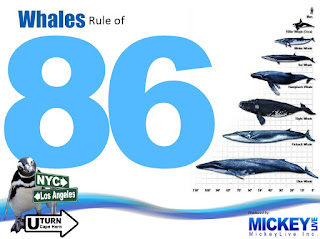
Then there are Whales.  As we planned our trip I definitely hoped to see a whale or two.  Apparently I wasn't the only one because Mickey Live did a lecture on whales.  There are 86 different kinds of whales out there.  If we were lucky, we had a chance to see one of three or more species of whale. 


The three species of whales that we might get to see were the Orca (commonly called Killer Whales), the Minke, and Humpback.  In the chronology of our trip this would be the 6th day.  Tomorrow we would be entering the Beagle Channel and heading toward Ushuaia, Argentina, the city that calls itself "The end of the World".

Following this same chronology, this was the day I saw my first Orca.  

We were heading south (duh!) along the coast of Argentina and Mandy and I were sitting by the window in a coffee shop on the 5th deck (we spent a lot of time in a coffee shop by the window on the 5th deck).  Out of the corner of my eye I saw what I thought was a dolphin jumping.  Upon closer examination I realized the dorsal fin was way too long and when the whale came out for air I could clearly see the white underbelly (don't get a lot of that on dolphins).  I didn't try to take a picture because, well, taking pictures through the window isn't what the cool kids do.

Humpback:  For me, the big goal of the trip was the Humpback whale.  As whales go, the Humpback is the 4th largest species.  They grow up to 52 feet long (the size of a school bus) and weigh in at over 60,000 pounds (some are as much as three tons over 60,000 pounds).  These marine mammals can be found literally all over the planet.  They don't get up to the Arctic, but I've seen them in Oregon, San Francisco and the inland Alaska passage near Juneau.   

The Orca is pretty small as whales go.  The females range between 3,000 and 6,000 pounds.  The males run twice that size.  A big male Orca can grow to 26 feet long (that would be about 8 feet longer than a Chevrolet crew cab pickup with a full size bed.  The orca is the biggest member of the dolphin family and they like to hunt in packs (not unlike wolves).  A hunting group (called a pod) can contain as many as 40 whales.  The female orcas lead the pod (they are a matriarchal society) and these whales typically live 50 to 80 years.

Minke: There are two known species of minke whales; the north Atlantic minke and the Antarctic minke (guess which one we were most likely to see).  Minke whales are in the same family as the blue whale and the humpback whale.  They are the most plentiful in this family (called the Rorqual family of whales).  Minke whales are a bit shorter (up to 24 feet long) and a bit heaver (up to 22,000 pounds) than Orcas.  The females typically grow a little bigger than the males.  These whales are filter feeders meaning they have Baleen bristles  (think of the bristles on a comb) that allows them to pass water through the filters and trap the food.  They filter out and eat small fish, krill, cod, herring, capelin and pollock.  For the most part minke whales travel alone or in small pods of 2 to 3 whales.  They can hold their breath for up to 25 minutes and have been know to swim at speeds of up to 24 miles per hour.

Sunday, February 18, 2018

Drakes Passage

Look at the bottom of a globe.  Find Antarctica and check out what is above it.

Water.  No land, just water.  Look any other place on the globe and as you turn the globe you will find land masses that serve as wind breaks and current deflectors.  At the bottom of the globe there is none of that.  The currents and the wind are free to run wild and unobstructed.

The Bottom of the Earth (Google Earth)
This is the only place on the planet where there is nothing to deflect the wind and the water and as a result, this is the place on the planet with the most powerful winds and the roughest seas.

If you examine the place where the Antarctic Peninsula reaches up toward South America, you see that this is a choke point where the path between Antarctica and any continent to the north is the smallest.  There is an 800 kilometer (480 mile) gap between the two continents and all the water that pushes up against South America can only squeeze by on the bottom through this tiny gap. 


The result of that is some of the strongest and most dangerous currents on the planet.  That should be enough to make us understand why the passage is scary, but there is more!

The currents in the Pacific ocean come down along the west coast of South America and then turn back up north, then east when they push against Antarctica.  Meanwhile, the currents of the Weddell sea run in a counter clockwise direction and are heading westward as they meet the eastward current from the Pacific Ocean.

So what happens when a powerful current heading eastward off the Pacific meets a powerful current heading westward off the Weddell sea?


Well...let's just say that memories are made.

Saturday, February 17, 2018

Penguins, Whales, and Drake's Passage

Day 05 and 06 were sea days and sea days mean more educational lectures.  I learned about many things but most memorable (for me anyway) were three subjects; Penguins, Whales and Drake's Passage.  I'll create separate blogs about Whales and Drake's Passage, but here's what I found interesting about the Penguins.


We learned that there are 17 species of penguins, but on this trip we were likely to see four of them.  We also learned that penguins and their eggs are not sought as a food source for humans resulting in penguins having on natural fear of the human species.

Penguins live almost exclusively in the southern hemisphere (I have to say almost because the Galapagos penguin has been known to wander north of the equator from time to time).  With the exception of the Galapagos penguin, all the others need a cold water climate to survive.

King Penguin:  The king is the largest of the penguins we might see (and the second largest species of penguin behind the emperor penguin).  Here are some King Penguin fun facts:

  • They average 3.1 feet tall and weigh around 33 pounds. 
  • There are currently between 2 and 3.2 million breeding pairs of these penguins. 
  • We wouldn't be likely to see these animals while we're in Antarctica because they like to hang out in Sub-Antarctic areas between 46 and 55 degrees south.  The good news was the Michelle booked an excursion for us when we visited Ft Stanley in the Falkland Islands (51 degrees south) where we would go to a rookery with King penguins so we would see some up close and personal on the way back.
  • King penguins don't make a nest.  They lay one egg at a time and carry it around on their foot for the full 55 day incubation period.
  • The penguins have a flap of skin that flops over the egg to keep it warm.
  • Every 6 to 18 days the egg is passed from one parent to the other.  The one who gives the egg up then waddles back to the ocean, dives in and heads out on an extended food foraging trip. 
  • The food they like to eat mostly fish, squid and other forms of sea life, but unlike most other species of penguin, the King's don't much care for krill.
  • Once the egg hatches the chick stays on a parent's foot for the first 30 to 40 days while it grows big enough to provide it's own warmth.
  • The chick commonly waits between 3 and 14 days between parents swapping duties (and the chick being fed)
  • King penguins dive as much as 1600 feet deep and walk up to 60 miles a day.


The best King Penguin story: During the lecture we were told that during last year's cruise a Japanese gentleman handed the camera to his wife and "Take a picture of me hugging this penguin!".  He walked over to the King penguin, that was about the size of a 5 year old child.  The penguin watched him but did not try to escape.  The man then reached around and grabbed the penguin in a big hug.  The penguin quietly pulled his leg back and kicked the man so hard that it shattered the man's leg.  The man fell to the ground in a pile and the penguin simply walked away.

Apparently when you swim hundreds of miles chasing down your dinner and you walk 60 miles a day in those funny penguin baby steps you build up extremely strong legs.

(When the lecturer told us this story the crowd cheered when the penguin broke the guy's leg).

Magellanic Penguin: Probably the most amusing thing about the Magellanic Penguin is the trait that gave this penguin the nickname "Jackass Penguin" based on how they sound.


You Tube Video by Brett Bartker


These are probably the easiest penguins to identify because of the distinctive white feathers with parallel black feathers that circle their eye.  They got their name from the maritime explorer Ferdinand Magellan who was the first to record the animal during an expedition in the year 1519.  They can be found as far north as 40 degrees of latitude all the way to the southern most tip of South America.

  • They are typically between 2 and 2.5 feet tall.
  • They weigh between 6 and 19 pounds.
  • They can swim at an upper speed of 22 miles per hour.
  • The Magellan Penguin is highly sociable and likes to live around numerous other penguins in large colonies.
  • They prefer sardines, cuttlefish, squid, and krill but eat a number of other aquatic animals.
  • These penguins are a tasty snack for leopard seals, large fur seals, sharks and Orcas.
  • The Magellanic penguin is listed as an endangered animal. 

Chinstrap Penguin: The chinstrap penguin is so named because of a band of black feathers that runs from their black skull cap down under their chin.  They live in the Antarctic islands, Antarctic Peninsula, and Circumpolar regions.

The Antarctic region where these penguins live has the strongest winds on the planet.  To keep their eggs from blowing away, these animals like to line their nests with small stones.  Unfortunately, even though they breed on rocky coasts as far away from ice as possible, the areas typically have shortage of the small stones that are needed.  The result is that the penguins are commonly involved in squabbles and most of the penguins are experienced kleptomaniacs that take nesting material from any other nests that are not adequately guarded.  The stones circulate between nests as they are stolen, claimed back, and then stolen again.


  •  The average size is 27 inches tall
  • Average weight is 10 pounds
  • There are an estimated 8 million of the birds and colonies can number in the hundreds of thousands.
  • The feed almost exclusively on krill.
  • These penguins are the lowest concern for endangerment.
  • Most humans will never see a chinstrap penguin out of captivity.
  • When they aren't on land the chinstrap penguins will often toboggan along by sliding on their stomachs.

Gentoo Penguin: I guess I saved the best for last.  The third largest penguin (behind the Emperor and King) the Gentoo is my personal favorite.  This happened when the lecturer told me that the Gentoo is the penguin that is most likely to untie your shoes.

Some Gentoo Penguin facts:


  • Average life span is 15 to 20 years.
  • Average size is 30 inches tall and 12 pounds.
  • Like the chinstrap, the Gentoo lives in the antarctic peninsula and surrounding islands.  For this reasons, most humans will never see a Gentoo outside captivity.
  • The Gentoo is the fastest penguin.
      
  • Gentoos are highly nurturing parents and often form long lasting bonds with their offspring.
  • They lay two eggs each year and the parents take turns incubating them for up to a month at a time (while the other parent goes out after food)
  • In pursuit of food  (fish, squid, and krill) they can dive down as deep as 655 feet and remain under water for as much as 7 minutes at a time.
As stated earlier, the Gentoo does not consider humans to be any kind of a threat and as long as people are not approaching their nesting areas, these penguins are quite happy to carry on a conversation with us.  If you see a group walking in a certain direction and then take a seat ahead of where they seem to be heading, the Gentoo won't change course to avoid you.  If that means jumping up on your lap as he passes by, he's fine with that.  If the penguin happens to notice your shoe laces while passing through it may become curious and tug on the laces while exploring what he has found.  The following video shows how terrified a baby Gentoo is when he comes across a human.


The natural predators of the Gentoo penguin are leopard seals, sea lions and orcas.  I found this video (the following one, not the former) on you tube and found it to be interesting for three reasons.  First, it was cool to see a penguin escape certain death as a killer whale snack, second once the penguin jumps into the boat to avoid the whales, the natural curiosity kicks in and the penguin immediately begins to check the people out.  This interest in people is why the Gentoo is my favorite.


Friday, February 16, 2018

A River in the Sea

Educational Crap #02

Consider this photograph that I pulled off of Google Earth.   This is the southern half of South America.

Image courtesy of Google Earth

If it isn't obvious, the light blue part around the land is part of the southern continental shelf and the dark blue part is deep water of the Atlantic Ocean on the right and the Pacific Ocean on the left. 

Here's a closer look at the portion of the above picture where Buenos Aires is located:

Image courtesy of Google Earth

There are two interesting things to learn here.  First is that Buenos Aires is not on the Atlantic Ocean. In fact, the city is over 175 miles away from the Atlantic.  The water that Buenos Aires is located on is the delta of the Silver River (Rio de La Plata).

When Mandy and I arrived we quickly noticed that the water was not the deep blue that one is used to seeing upon boarding a cruise ship.  This water looked very muddy, so much so that there was a bit of Ewwww! in our conversation about people we saw on the beach.  We didn't think it would be a wonderful experience swimming in the muddy waters. 

Rio de La Plata Delta from Google Earth

Rio de La Plata Delta - Satellite image
All of our sailing on the first day of our cruise was in the muddy water of this river.  When you think about it, the water being brown in this part of the river (the Delta) wasn't really that strange.  The river that feeds into the delta goes north as far as Paraguay and beyond so bringing sediment that discolors the waters on the coast of Buenos Aires is quite reasonable.

The second interesting thing to learn here is that the water is an average of 13 feet deep.  That may not seem interesting at first, but when you consider that our ship has a draft that is nearly three times that deep you realize that 13 feet is quite shallow.

While we were eating dinner the first evening I glanced out the window and noticed another massive ship that was so close that it looked like it was touching our rail.  At the time I thought is was one of the craziest things I had ever seen.  

It turns out that we sail the first few hundred miles of our journey in a narrow river that exists in the delta.  The river in the delta is constantly dredged to allow the port of Buenos Aries to stay open. 


Picture courtesy of Mickey Live

The path of the river we followed (shown above) only has two or three places wide enough for two ships to pass so for the most part this "River in the Sea" is a one-way passage.

Friday, February 9, 2018

Longitude and Latitude

Educational Crap 01

Longitude and Latitude


In a song that I really loved Paul Simon says

"When I think of all the crap I learned in High School, it's a wonder I can even think at all"

I often pondered how different interests draw us into totally separate views on what knowledge is important and what is among the "crap" we were forced to learn.

For my part, I always liked maps and actually paid attention in my geography class.  One of the things you learn in geography is latitude and longitude and I expect most high school students are sure there is no possible value in such education, but I'm here to tell you that it is packed with fun facts (and on a trip like this it has real value).

In a nutshell longitude and latitude are about wrapping the planet in graph paper.  By doing this we can pinpoint anything in the world and attach an exact position that essentially says "it's this far up and down, and this far left and right".

Longitude is lines up and down that are used to measure east and west.  The two interesting things are the prime meridian (which is zero on our count to 360 degrees around the ball, and the international date line (which is sort of on 180 - opposite from the prime meridian, but does some crazy twisting and turning to avoid land).  For this trip I didn't care much about longitude (we didn't cross any of the cool stuff).

Latitude is what got really interesting as we headed toward the south pole.

Latitude is used to measure the earth from top to bottom.  It consists of rings around the planet horizontally.  The equator is the middle.  90 degrees north is the north pole.  90 degrees south is the south pole.  Here's some interesting things about latitude:

  • The earth rotation has some wobble relative to the sun so the place on earth that is closest to the sun changes.

       > At the start of spring and fall the closest point to the sun is on the Equator

       > At the start of summer the closest point to the sun is 23.5 degrees north (the latitude that includes Durango, Mexico).

       > At the start of winter the closest point to the sun is 23.5 degrees south (the latitude that includes Santos Brazil (just south or Sao Paulo)
     
  • Because of the earth's tilt summer in the northern hemisphere (north of the equator) is winter in the southern hemisphere (south of the equator).  Winter in the north is summer in the south.
     
  • As you move north or south from the point on earth that is currently closest to the sun, the temperature drops because you are moving farther from the sun.
     
  • There are 5 major circles of latitude.  Artic circle (66.33 degrees north), Tropic of Cancer (23.26 degrees north), Equator (0 degrees) Tropic of Capricorn (23.26 degrees south), and Antarctic Circle ( 66.5 degrees south)
     
  • The tropics (area between tropic of cancer and tropic of Capricorn) houses the part of the earth that is closest to the sun (covering the wobble)
  • The artic circle (66.33 degrees north) is the northern latitude where it stays light (or dark) for a full 24 hours. 
     
  • The Antarctic circle (66.5 degrees south) is the southern latitude where it stays light (or dark) for a full 24 hours.
     
  • Moving north or south from the spot closest to the sun changes the length of the days (summer they get longer, winter they get shorter).
     
  • When we set sail, the day was 15 hours and 30 minutes long.  (assuming it got light 30 minutes prior to sunrise @ 5:49 a.m. and it got dark 30 minutes past 8:11 p.m.)
     
  • When we reached Antarctica the day was 18 hours 45 minutes long (based on the same assumptions above, even though they were now false, with sunrise at 4:15 a.m. and sunset @ 10:02 a.m.)  The reason the assumptions from the previous bullet were false is because as we approached the south pole the sun couldn't get much past dusk (when it has set but hasn't dropped far enough below the horizon to stop providing light).  It was actually still light when I went to bed at around midnight because the sun doesn't get very far below the horizon.  The dark actually only lasts around 3 hours with 21 hours of light.

    When we started heading north again I remember there was a day when Mandy and I noticed it was dark at 11 p.m. and we thought it was strange for it to be dark that early.
     
  • The south ocean (and Antarctica) starts at 60 degrees of latitude south.
     
  • Mandy and I traveled south 97.62 degrees south from Dallas Texas (32.77 degrees north) to Paradise Bay Antarctica (64.95 degrees south).  This distance is farther than the distance from the equator to the north pole).
     
  • The temperature dropped over 70 degrees Fahrenheit while we were on-board the ship.

Ignorance Reduction

MickeyLive

Ignorance Reduction While Cruising

Slide courtesy of Mickey Live Inc.

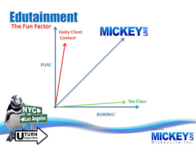
What's more fun than a tax class but not quite as delightful as a hairy chest contest?  Education or, more accurately, the combination of education and entertainment.  Edutainment is a new thing I'm starting to see on ships as I cruise.

As we sailed from Sydney, Australia to Seattle we had lectures on subjects from "The History of Rock n Roll" to "How Much Starwars Technology Actually Exists Today".  I liked the concept and now keep a constant eye out for such things when cruising.

There were three such lecturers on our ship as we sailed toward the south pole; Dr. Dave who talked about nature and wildlife, Peter Lasorsa who talked about security and identity theft, and by far the most talented...Mickey Live.

The skilled among us (like Virginia Cotton) will quickly see that Mickey has his nerd on.  Otherwise you wouldn't represent your value on a graph and you wouldn't quantify fun as a factor.  The nerd part of the presenter was quite refreshing!

Throughout my writings about my trip I will be using things I learned from the MickeyLive lectures.  I will also share a photograph from the snapshot rally from time to time.  When I do, I will leave the MickeyLive overlays on the photos so you know the images are not mine and I don't have any distribution rights (so please enjoy them but do not copy them).  The images that don't have the MickeyLive logo on them are mine and not only am I giving you permission to copy them, but drop me an email and I'll send you the original (which will likely be 16 megabytes in size and in the raw Nikon format).


Thursday, February 8, 2018

Day 03 - Getting Aboard


Day 03 - Getting Board

I did a survey yesterday about cruising.  They asked me how many cruises I have been on and the choices were 1, 2,3,4, and 5.  I needed the numbers that were up in the 30s.  Cruising has been my vacation of choice for nearly 35 years because back in the days when my kids were being born I learned that my pager didn't work on board ship.  Once we pushed away from the dock, I was unreachable and unreachable was truly "on vacation".  I don't need protection from a pager anymore, but now cruising is about an inexpensive vacation.  Truth is if you are going to travel there are choices packed with better bang for the buck.  Cruising, for me, is about value.  Not this cruise (turns out a trip to Antarctica is not an inexpensive undertaking) but cruising in general.


So day 3 starts.  I woke up a little late that morning.  Not surprising because day 1 and day 2 were fused into a single day.  Also not surprising because the clock in Argentina was running 3 hours later than the one in Dallas.  A little late wasn't a problem, though, because it takes them half the day to off load last weeks passengers.

I looked out my window and saw that the taxi cabs were lining up to help me get to my ship.  It was boarding day.

For me, boarding day is always a mixed bag of happy and sad.  The sad part has to do with getting into a line with between 2,000 and 8,000 other happy cruisers to go through the embarkation process. 

The happy part is when you finish the lines, security, and paperwork.  They hand you this little plastic card that is your room key, ID, and money, but more importantly, it is a symbol that the boarding process is over.


 Not so on this cruise.  It started out the same.  Same lines.  Same security.  Same paperwork and health screening.  Same plastic card (followed by the same euphoria but this time the joy was premature).

This cruise they give you your little plastic card then put you in another set of lines that take you through the process of exiting Argentina (emigration?), confiscates our passport and then puts us on a bus that drives around the port for 20 minutes and finally dumps you off in front of the ship.

Next is a quick walk up a steep gangway and it's finally euphoria time.


There are plenty of additional embarkation day activities.  Exploring the ship (we didn't do that), rushing to the cafeteria to overeat for the first time (we didn't do that), trudging to your assigned deck and finding your stateroom (we didn't do that either).  For us, it was drag out the Kindle, park in front of a window at the front of the ship, and wait for the little tug boat to pull us out of the harbor.

The sea part of our voyage to Antarctica has begun!

Wednesday, February 7, 2018

Day 02 - Buenos Aires

Day 02 - Buenos Aires


On the drive from the airport to our hotel we passed the Obelisco de Buenos Aires which is a monument built in 1936 to commemorate the 400th anniversary of the first foundation of the city.  It stands on the spot where the Argentine flag was officially raised for the first time in 1812.  The monument was built in 31 days (yup, that fast) at a cost of 200,000 pesos.

If you are amazed by this picture don't get too impressed with me.  I didn't take it.  I don't even know who did, but if you want the original you can find it on Google!

While we're enjoying pictures I didn't take, here's another one for you.  This one came off the Sheraton web site but it gives you a pretty good mental image of where Mandy and I stayed (because it is a physical image of where Mandy and I stayed).


I did, however, take the picture below from the window of our hotel.  This clock tower, called Torre Monumental (renamed in 1982 from "Torre de los Ingleses").  The tower was a gift from the local British community to commemorate the centennial of the May Revolution of 1810.


So now I suppose some of you are thinking history of a clock tower.  Ya, ya, ya.  Blah, blah, blah.

If you are, however, you are missing the two fun facts.

The first fun fact was that we could see it out our hotel window because my little daughter got us a fancy suite in the hotel (yes, that's right...she's fancy).

The second fun fact was probably obvious to you history buffs.  Torre de los Ingleses means "Tower of the English".  Obviously this means that back in 1909 the Argentinians must have been fond of the British. Why then, would they rename the tower to "Monument Tower" in 1982?

Obviously they still want to remember SOMETHING when they look at the tower, and that something will be revealed on the Day 14 Blog.  Stay Tuned!!

Why We Do Filters

Why We Do Filters

Every serious photographer has a phobia.  It isn't that we lay awake at night worrying, but I expect we all get little chills from time to time when we slip and almost drop a camera or a lens.

High end cameras and lenses cost literally thousands of dollars.  The thought of dropping one and having it break is always unpleasant.  During the flight on day one (or maybe day two, the flight transcended the 2) those imagined nightmares came true.  It wasn't NETFLIX "Stranger Things" scary, but it's a guarantee that your heart will skip a beat (I know mind did)


If you fly very much you've heard the "Be careful when opening the overhead bins as items inside may have shifted" shpeal.  I guess it's true, stuff can move around and at some point during the flight the bin was opened and my camera bag came tumbling out.  I watched in slow motion as the bag turned end over end multiple times and finally crashed into the aircraft floor.

My exclamation was right out loud (but I don't think I yelled, I just said it).

"Well, that can't be good!"

I didn't even open the bag.  I just picked it up, put it back in the overhead and took my seat.   The next day in Buenos Aires I went through the bag and found bad news and good news.  The bad news was that one of my lenses was spilling out broken glass.

The good news was that it was the UV filter doing what we REALLY put them on the lenses for.  It took the shot and although the $30 filter was destroyed, it protected the much more expensive lens.